For boaters seeking dependable navigation, these GPS units cover handheld and chartplotter options with durable builds, water resistance, and coastal mapping. Best for anglers, cruisers, and day-trippers who need accurate location data, reliable charts, and easy-to-read displays on the water. The following selections balance portability, screen visibility, and chart coverage to suit different boating styles and budgets.
| Product | Type | Display | Chart Coverage | Best For |
|---|---|---|---|---|
| Garmin GPSMAP 79sc | Handheld | Color, floating | BlueChart coastal | Rugged, floating handhelds for open-water and back-up navigation |
| Garmin eTrex 22x | Handheld | Color, 2.2″ display | Topo Active maps | Compact, affordable option for basic navigation on land and water |
| Garmin GPSMAP 86Sci | Floating handheld | 3″ color | BlueChart coastal, inReach capable | Integrated marine data with satellite messaging on the water |
| Garmin ECHOMAP UHD2 94sv | Chartplotter | 9″ touchscreen | Navionics+ coastal | Advanced chartplotter for fixed-mount vessels |
| Simrad GO9 XSE | Chartplotter & MFD | 9″ touchscreen | Navionics+ charts via Discover card | All-in-one MFD with sonar, radar, and mapping |
Keep in mind that each option has distinct use cases. Handheld models excel as backups or portable solutions, while full chartplotters offer comprehensive display integration on larger boats. The right choice depends on whether you value portability, screen size, built-in sonar capabilities, or satellite connectivity.
Garmin GPSMAP 79sc Handheld GPS — Rugged Floating Design

The GPSMAP 79sc is a rugged, floating handheld with a high-resolution color display and scratch-resistant glass. It supports multiple satellite constellations for global tracking and includes BlueChart coastal charts. This model is best for boaters needing a durable, water-ready backup device that can be hand-carried or used on deck.
Best for: small- to mid-size boats, coastal day trips, and scenarios where a floating handheld is preferred. It’s well-suited as an emergency backup or secondary navigation device during shore-to-boat transfers.
Key considerations: Floating design helps prevent loss, but screen readability in direct sunlight may vary under bright glare. Memory supports 10,000 waypoints and 250 routes, which is ample for many voyages.
Garmin eTrex 22x — Rugged Handheld Navigator

The eTrex 22x offers a reliable handheld navigation experience with a 2.2” sunlight-readable color display and topographic maps preloaded for outdoor routing. It’s designed for durability and long battery life, making it a solid choice for anglers and hikers who need dependable navigation on land and water.
Best for: budget-conscious boaters who want a simple, durable handheld with preloaded topo maps and straightforward navigation. It’s particularly useful as a secondary device on deck or for shore excursions where a compact unit is advantageous.
Caution: The device’s smaller screen size may reduce readability in choppy water or low-contrast conditions; ensure the display remains legible in your typical lighting environment.
Garmin GPSMAP 86Sci — Floating Handheld with InReach

The GPSMAP 86Sci combines a floating design with a 3” sunlight-visible display and button operation for ease of use on the water. It can stream boat data from compatible chartplotters and instruments, and ships with BlueChart coastal charts that blend Garmin and Navionics data for expanded coastal coverage.
Best for: boaters who value satellite connectivity (InReach capable) and integrated data streams on a compact handheld. Ideal as a high-visibility, easy-to-use backup or secondary navigator on smaller craft.
Caution: While feature-rich, it is a handheld device; consider mounting or securing it to prevent loss in heavy seas or rough weather.
Garmin ECHOMAP UHD2 94sv — 9″ Chartplotter

The 9” ECHOMAP UHD2 UHD2 94sv chartplotter provides a bright, responsive touchscreen with Navionics+ coastal charts included. It comes with a GT56 transducer for traditional, ClearVü, and SideVü sonar views, delivering clear bottom detail and improved target identification.
Best for: larger boats or when a fixed-mount chartplotter is preferred for integrated navigation and sonar. Choose this if you want comprehensive coastal coverage plus advanced sonar features in one display.
Limitation: As a fixed unit, it lacks the portable flexibility of handheld devices; installation and vessel mounting considerations apply.
Simrad GO9 XSE Chartplotter — MFD with 83/200 Transom Transducer

The GO9 XSE is a multifunction display that combines GPS navigation, sonar, and more. It includes a C-MAP Discover card with Vector Charts, tides, and currents, plus an HDI transducer for CHIRP sonar and DownScan Imaging to help identify underwater structure and fish targets.
Best for: sportboats and center-consoles that want a capable, all-in-one MFD with modern sonar and charting. It’s a strong choice when upgrading to integrated vessel-wide navigation and fish-finding capabilities.
Caution: Requires integration with other boat systems and potential accessory purchases (radar, transducers) to maximize its full potential.
Garmin GPS 73 — Pocket Marine GPS
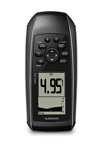
The GPS 73 offers 2.6 inches of display, sailing-focused features like virtual starting line, countdown timers, speed history, and tack assist. It also includes marine alarms and MOB features, with long battery life on AA power. This device is a compact, purpose-built handheld option for sailors who need race-ready or routine navigation on small boats.
Best for: sailors and small-boat users who value sailing-specific functions and extended battery life in a portable unit. It’s a practical choice for back-up navigation on the water and shore-to-boat routines.
Caution: The smaller screen and basic chart options mean it may not replace a full chartplotter on larger vessels or in high-traffic channels.
Buying Guide
What should you consider when buying a GPS unit for boating?
- Purpose and setup: Decide between handheld units for portability or fixed-mount chartplotters for on-board navigation and integrated sonar.
- Display size and readability: Larger screens improve readability in bright sun and rough seas; consider glare-resistant displays and glove-friendly interfaces.
- Charts and coverage: Look for BlueChart, Navionics+, or preloaded topo maps that suit your cruising area and activities.
- Connectivity and sonar: If you need sonar, consider models with CHIRP, DownScan, and compatibility with transducers and other instruments.
- Durability and water resistance: Floating handhelds are ideal as backups; IP ratings and rugged casings matter for open-water use.
- Power and battery life: For handhelds, longer life reduces the need for frequent recharging; fixed units rely on vessel power.
FAQ
- What is the difference between a handheld GPS and a chartplotter?
– Handheld GPS units are portable and often used as backups or for on-shore use, while chartplotters are fixed-mount devices designed for full onboard navigation with integrated sonar and larger displays. - Do these devices support coastal and offshore charts?
– Most listed models include BlueChart or Navionics+ coastal charts, with some offering preloaded maps and compatibility with additional chart cards. - Is a floating handheld GPS necessary for boats?
– It’s beneficial for open-water use and as a rescue backup, reducing the risk of loss if dropped overboard. - Can I use a handheld GPS with sonar on a boat?
– Some models support sonar integration or can pair with compatible chartplotters and instruments; check system compatibility for your vessel. - Which GPS unit is best for a small sailboat?
– A compact handheld like the GPSMAP 79sc or GPS 73 works well as a portable backup or race-focused tool; fixed MFDs offer more features on larger boats.