Looking for reliable marine GPS devices that focus on navigation and mapping rather than fishfinding features? This guide highlights five options with strong GPS and chart capabilities, suited for sailors, boaters, and coastal explorers who prioritize routes, waypoints, and coastal charts. The top picks include rugged handhelds that float and water-resistant models, plus chartplotters that can be paired with separate transducers if needed. A quick comparison table follows to help you decide at a glance.
| Product | Type | Best For | Key Benefit |
|---|---|---|---|
| Garmin GPSMAP 79sc | Handheld GPS | Coastal and offshore travelers | Preloaded BlueChart g3 coastal charts, floats in water |
| Garmin GPSMAP 79s | Handheld GPS | Rugged outdoors, floating use | Worldwide basemap, high memory, float design |
| Garmin ECHOMAP UHD2 53CV | Chartplotter with fishfinder | In-dash navigation with charting | Color display and dual sonar options |
| Humminbird Helix 5 G3 | Chartplotter with fishfinder | Freshwater and coastal navigation | Basemap plus optional premium charts |
| Garmin Striker 5CV | Fishfinder/chartplotter | Compact navigation with sonar | CHIRP sonar integration, quickdraw contours |
Note: The list leans toward GPS-focused devices, with some entries offering optional transducers or separate fishfinding options. If your priority is navigation-first devices with robust charting, these selections provide strong basemaps, waypoint management, and reliable satellite tracking for diverse boating environments.
Garmin GPSMAP 79sc, Marine GPS Handheld

The Garmin GPSMAP 79sc is a rugged, floating handheld GPS designed for challenging marine environments. It features a high-resolution color display and scratch-resistant, fogproof glass. The device uses BlueChart g3 coastal charts and supports multiple satellite constellations for reliable global tracking. Best for boaters who need a durable, portable navigation tool with memory for many waypoints and routes.
Best for: Coastal cruisers and offshore travelers who want a floatable, water-resistant GPS with extensive chart coverage. This unit is ideal when you need a reliable backup navigator or a handheld solution for dinghy or tender use.
Limitation: While strong in navigation, it is not a dedicated fishfinder; pairing with a separate sonar system is possible if sonar data is required.
Garmin GPSMAP 79s, Marine GPS Handheld

The GPSMAP 79s shares the rugged, floating design with enhanced memory and a reliable global tracking setup. It includes a worldwide basemap and the ability to store up to 10,000 waypoints and 250 routes, as well as 300 fitness activities. Built to withstand harsh marine conditions, this model supports multiple satellite systems for stable navigation in remote areas.
Best for: Mariners who require a floating, tough handheld with long-term waypoint storage and wide global coverage. Great as a secondary device or for hands-on navigation on deck, anchor, or tender runs.
Limitation: It does not inherently include fishfinding sonar; consider separate sonar if you need underwater imaging.
Garmin ECHOMAP UHD2 53CV Chartplotter

The Garmin ECHOMAP UHD2 53CV is a compact chartplotter with a 5-inch color display. It offers Garmin CHIRP traditional sonar and ClearVü scanning sonar options for dual-view sonar on compatible setups. This unit emphasizes charting and navigation, with Wi-Fi for sharing data between compatible chartplotters. Best for: Boats needing a compact, high-clarity navigation screen with optional sonar expansion.
Limitation: Information provided focuses on chartplotter and sonar compatibility; the model’s core GPS navigation relies on charts rather than standalone sonar expertise.
Garmin Striker 5CV with Transducer
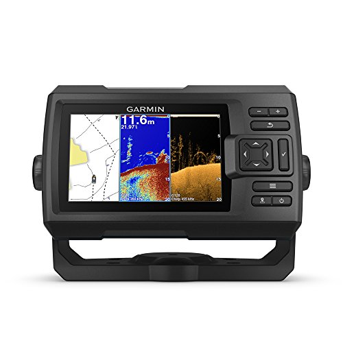
The Striker 5CV combines GPS navigation with built-in CHIRP traditional sonar and CHIRP ClearVü scanning sonar via the included GT20 transducer. This model supports Quickdraw Contours mapping for creating user-generated depth maps. Best for: Small crafters seeking a compact unit that provides both navigation and sonar data in one package.
Limitation: While navigation features are solid, the primary emphasis is on sonar; use as a dual-function device if you require robust charting beyond basic maps.
Garmin Striker 4 with Transducer

The Striker 4 offers a 3.5-inch display with CHIRP sonar and built-in GPS for marking waypoints and routes. It supports depth ratings suitable for freshwater and coastal zones and includes a waypoint map to navigate to key spots like docks and brush piles. Best for: Budget-friendly navigation with essential waypoint and route tracking, plus basic sonar capabilities.
Limitation: Smaller display and limited screen real estate can hinder detailed chart viewing; consider larger models if extensive mapping is needed.
Garmin Striker Vivid 4cv

The Striker Vivid 4cv pairs a 4-inch display with vivid scanning sonar palettes to differentiate fish and underwater structures. It includes a GT20 transducer for CHIRP traditional sonar and CHIRP ClearVü scanning sonar, along with high-sensitivity GPS for waypoint and route tracking. Best for: Small boats needing a compact navigation device with enhanced sonar visualization for fishing grounds and structures.
Limitation: Smaller screen size may limit chart visibility; consider pairing with larger displays for more complex navigation tasks.
Buying Guide: Key Considerations for Marine GPS Units
What level of navigation do you need? For straightforward route planning and waypoint storage, handheld GPS devices like the Garmin GPSMAP 79sc or 79s are excellent backups or on-deck tools. If you require a fixed, in-boat display with chart plotting, consider compact chartplotters such as the ECHOMAP UHD2 series, which can pair with sonar options as needed.
Do you want built-in fishfinding or not? If you prefer GPS navigation without fishfinding, select models that emphasize charts, basemaps, and waypoint management. Some options in this list can support sonar when you add a transducer, but ensure you’re purchasing the right bundle or plan to upgrade later.
How important is display size and readability? Larger screens provide easier chart viewing and waypoint management, especially in bright sun. If you only need basic navigation, smaller handhelds are portable and sufficient. For fixed mounts, a larger chartplotter screen can improve situational awareness.
What about memory and coverage? Units with extensive waypoint storage, long battery life, and global satellite compatibility are beneficial for voyages far from shore. Check supported satellite systems (GPS, GLONASS, Beidou, Galileo, QZSS) for reliable tracking in varied conditions.
Transferability and compatibility: If you navigate with multiple devices, consider models that can share data across chartplotters or integrate with companion apps via Wi-Fi. This can simplify route planning and data syncing on larger boats.
Frequently Asked Questions
- What is the main difference between handheld GPS devices and chartplotters? Handhelds are portable and often rely on built-in basemaps, while chartplotters are designed for fixed vessel mounting with larger displays and more powerful charting features.
- Do any of these units come with built-in sonar? Some models listed include sonar options, but several are navigation-focused. For fishfinding, pairing with a transducer or choosing a unit with CHIRP is advisable.
- Can these devices operate without an internet connection? Yes. These devices rely on GPS satellites and preloaded charts; internet connectivity is optional for data sharing and updates on compatible models.
- Are rugged, floating GPS units worth it for offshore use? Absolutely for boats where devices may be dropped overboard or exposed to rough conditions; floating units reduce the risk of loss and ensure quick recovery.
- How important is chart detail for coastal navigation? Very important. Detailed coastal charts improve route planning, hazard awareness, and waypoint accuracy in busy waterways.