Choosing the best handheld GPS for boats is essential for marine safety, navigation accuracy, and convenience on the water. Handheld GPS units designed specifically for boating often include floating capability, water resistance, marine charts, and satellite communication features. Below is a summary table of the top handheld GPS devices ideal for boating, including both standalone GPS navigators and marine radios with integrated GPS capabilities.
| Product Name | Brand | Key Feature |
|---|---|---|
| Garmin GPSMAP 79s Marine GPS Handheld | Garmin | Floating, Rugged, Worldwide Basemap |
| Cobra MR HH600FLTBTGPS Handheld Floating VHF Marine Radio | Cobra | Bluetooth, GPS, Floating, VHF Radio |
| Garmin GPSMAP 86Sci Floating Handheld GPS | Garmin | BlueChart Coastal Maps, Satellite Communication |
| Uniden MHS338BT Floating Marine VHF Radio | Uniden | Bluetooth, GPS, Emergency Strobe, Submersible |
| Garmin eTrex 22x Rugged Handheld GPS Navigator | Garmin | TopoActive Maps, Sunlight-Readable |
Garmin GPSMAP 79s Marine GPS Handheld

The Garmin GPSMAP 79s is a rugged handheld GPS designed for marine use. It features a floating and water-resistant body with IPX6 protection, ensuring durability in aquatic environments. The device includes a high-resolution color display with scratch-resistant, fogproof glass, making it easy to read in various weather conditions.
Memory capacity is increased to store up to 10,000 waypoints, 250 routes, and 300 tracks for detailed voyage planning. Supporting multiple satellite constellations like GPS, GLONASS, Beidou, Galileo, QZSS, and SBAS, this model ensures reliable global tracking coverage. This device is suitable for boaters requiring an all-weather, dependable GPS handheld that floats and offers comprehensive waypoint management.
Cobra MR HH600FLTBTGPS Handheld Floating VHF Marine Radio
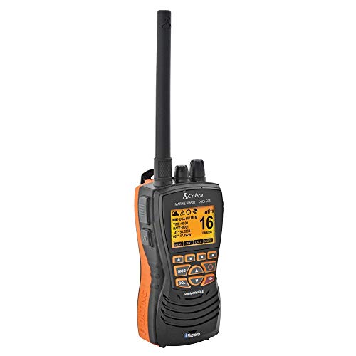
This device combines GPS tracking with a floating VHF marine radio. The Cobra MR HH600FLTBTGPS offers Bluetooth connectivity allowing calls directly from the radio, protecting your phone from marine conditions. It features a built-in GPS receiver to display coordinates and send your exact location via DSC calls, enhancing safety and emergency responsiveness.
Other notable features include a noise-canceling microphone, memory scan, backlit LCD display, and a replay function that records the last 20 seconds of incoming transmissions, essential for noisy environments on boats. The device supports full 1, 3, or 6-watt transmissions, NOAA weather channel access, and instant emergency channel 16 access. It is ideal for boaters needing communication with integrated GPS functionality.
Garmin GPSMAP 86Sci Floating Handheld GPS

The Garmin GPSMAP 86Sci offers a specialized floating design with a user-friendly 3-inch sunlight-visible display and physical button operation, optimized for marine navigation. It includes preloaded BlueChart G3 coastal charts integrating Garmin and Navionics data for detailed nautical mapping.
This model supports inReach satellite communication capabilities and the ability to stream boat data from compatible chartplotters and instruments, consolidating important vessel information in one device. Water resistance and floating design enhance usability in marine environments. This handheld GPS is perfect for users who want integrated coastal charts and satellite communication on the water.
Uniden MHS338BT Floating Marine VHF Radio

The Uniden MHS338BT is a submersible IPX8-rated floating marine VHF radio with integrated GPS and Bluetooth functionality. It features an emergency water-activated strobe light and flashlight for enhanced safety during nighttime or distress situations. This device has a drop-in charging cradle with a rechargeable Li-ion battery.
The radio transmits at full 6 watts with selectable power levels for extended range. GPS capabilities allow saving and retrieving favorite positions, while Bluetooth lets users connect the device to a smartphone app for text messaging and setup. NOAA weather alerts and FM radio are additional conveniences. This handheld is suitable for boaters needing a full-featured floating radio with GPS and emergency features.
Garmin eTrex 22x Rugged Handheld GPS Navigator

The Garmin eTrex 22x is a rugged handheld GPS ideal for outdoor navigation including boating. Featuring a 2.2-inch sunlight-readable color display with 240 x 320 pixels, it offers clear readability on bright days. Preloaded TopoActive maps include routable roads and trails, useful for both land and marine environments.
While it does not float or include marine-specific charts, it offers a dependable GPS experience suitable for boaters who want a solid handheld GPS unit with good map detail and water resistance. This device provides reliable positioning for navigational and waypoint tracking needs.
Buying Guide for Handheld GPS Devices for Boats
When selecting a handheld GPS for boating, consider the following key factors to ensure you choose a device that meets your marine navigation and safety requirements:
Floating and Water Resistance
Marine handheld GPS devices should have a floating design or buoyancy to prevent loss overboard. Confirm that the unit has at least IPX6 or IPX7 water resistance ratings. Submersible models with IPX8 ratings offer enhanced protection against water immersion.
Display Quality and Usability
A high-contrast, sunlight-readable display with good resolution improves visibility in bright marine conditions. Device size and button interface also impact ease of use when operating with wet hands or gloves.
Satellite Compatibility and Accuracy
GPS models supporting multiple satellite networks such as GLONASS, Galileo, and Beidou offer superior positional accuracy and reliability, especially in challenging environments or areas with partial coverage.
Marine-Specific Features
Look for devices with preloaded coastal maps like Garmin BlueChart or Navionics data for detailed nautical navigation. Integrated VHF radios with GPS allow seamless communication and emergency position reporting (DSC). Some models also include NOAA weather alert channels and marine communication features.
Memory and Route Management
Devices that store thousands of waypoints, multiple routes, and track logs provide more comprehensive trip management. This aids in precise navigation and emergency location tracking.
Battery Life and Power Options
Extended battery life or solar charging capability can be critical for long marine trips. Rechargeable batteries with external charging cradles add convenience for on-board power management.
Additional Safety Features
Emergency strobes, flashlights, noise-canceling mics, and Bluetooth connectivity for app integration enhance safety and communication capabilities on the water.
Comparing devices based on these criteria helps ensure reliable, versatile, and marine-appropriate handheld GPS technology for safe boating experiences.